
Fly by the numbers
1200.aero is the all-encompassing platform for operational data
1200.aero is the all-encompassing platform for operational data
Trusted by leading airports and aviation partners:


1200.aero integrates multiple data sources for a real-time view of the airport environment, including runways, ramps, gates, and ground operations, providing operational data for actionable insights.

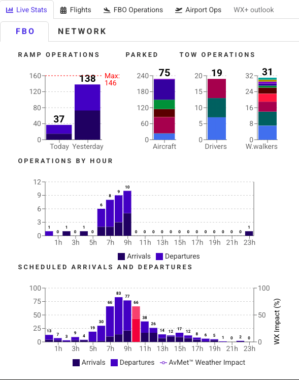
Real-time traffic in the air and on the ground, live CTAF/UNICOM/tower/ground audio, live operation counts, scheduled arrivals and departures, and parked aircraft.


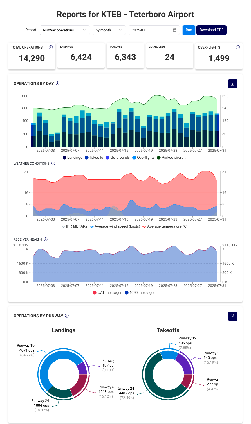
Reports featuring current and historical statistics over multiple time horizons, including:

Summary notifications for daily and monthly operations, inbound
flights, and aviation safety events such as near mid-air collisions
and in-flight emergencies.
Automated discovery of based aircraft on the basis of overnight stays.
Tracks last known location, days active, and tracking history.
May ops summary for KTEB: 14,330 operations by 3,480 unique aircraft (6,667 landings, 6,705 takeoffs, 15 missed approaches, 943 overflights).
Jun 1, 06:01 AMNear mid-air collision 11NM, 98° from KLAL on Wed, Mar 29 11:29 EDT: N234DS (TBM3), N54771 (PA28), lateral separation: 32ft, vertical separation: 205ft, track difference: 238°.
Sep 7, 9:34 PMIn-flight emergency (7600) 19NM, 68° from KFMY on Sat, Jan 25 13:58 EST: N1403R (C172).
Aug 29, 10:04 AM
Research noise complaints by street address, and define custom noise-sensitive areas to quantify activity.
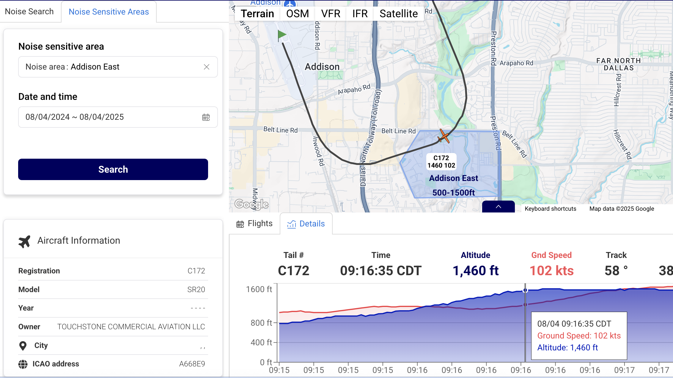

1200.aero equips airports with tools for tracking live and historical airport operations, parked aircraft and parking history, automated discovery of based aircraft, research of noise complaints and activity inside noise-sensitive areas, pavement utilization, automated detection of safety-related events, and tracking of ground equipment. The service also maintains a large warehouse of raw data to answer unforeseen questions about your airport in the future.

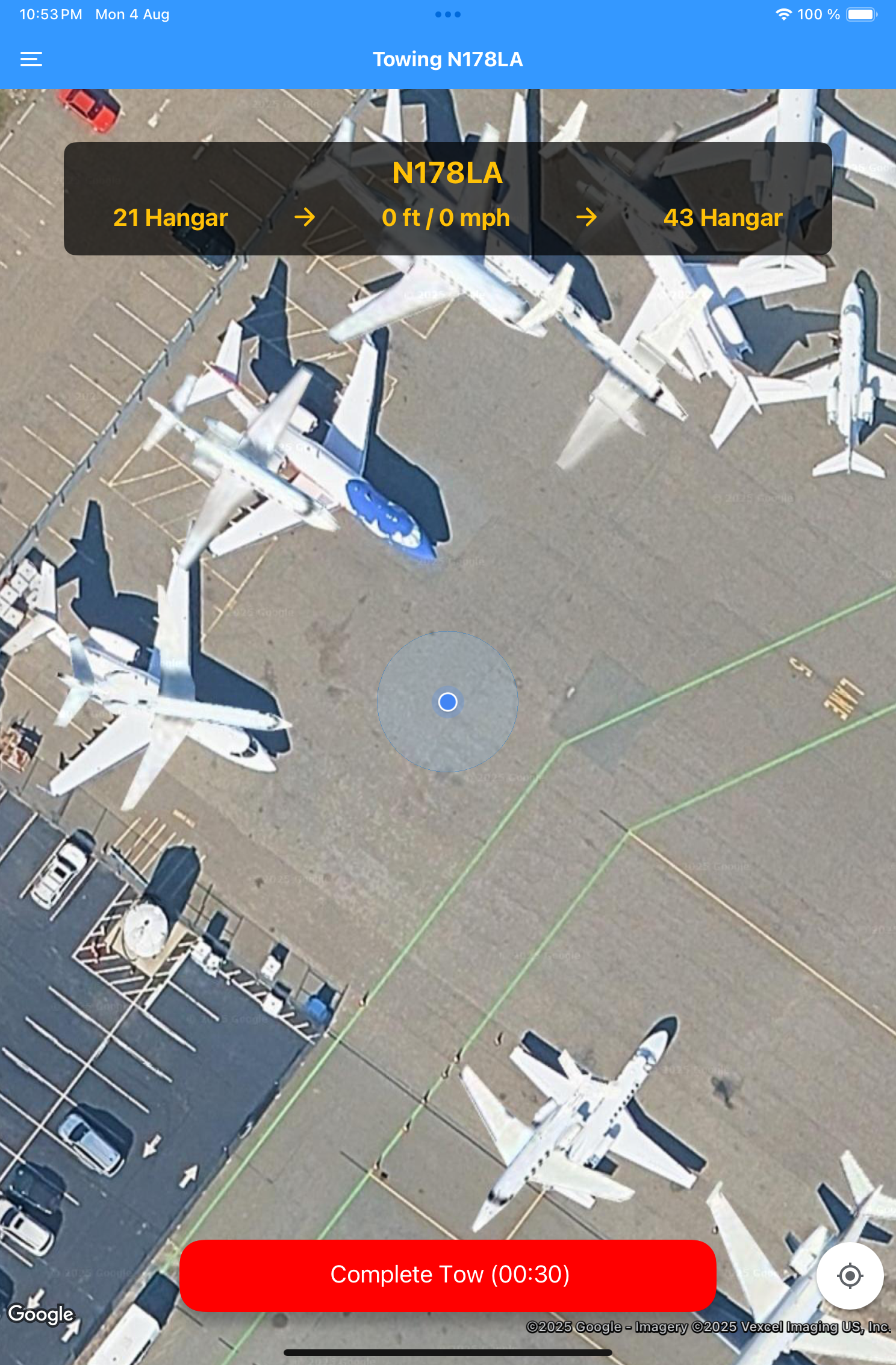
1200.aero provides a live view of your FBO, including live ramp arrivals and departures, current aircraft parking positions, ramp space utilization, and audio communications for tower, ground and ramp control frequencies. Our easy-to-use mobile app enables staff to document the condition of arriving aircraft using pictures and short notes, perform the pre-tow checklist, and track every second of aircraft towing from start to finish. A growing set of analytics track market share, length of stay, and staff towing workload.

Supporting flight schools with granular flight data—including taxiing and safety event notifications—alongside live and archived CTAF/UNICOM audio, offering instructors and students valuable tools for training and post-flight analysis. Its detailed movement logs and operational summaries also help schools monitor student progress and fleet usage, improving both safety and instructional outcomes.
Mobile application (Android and iOS)
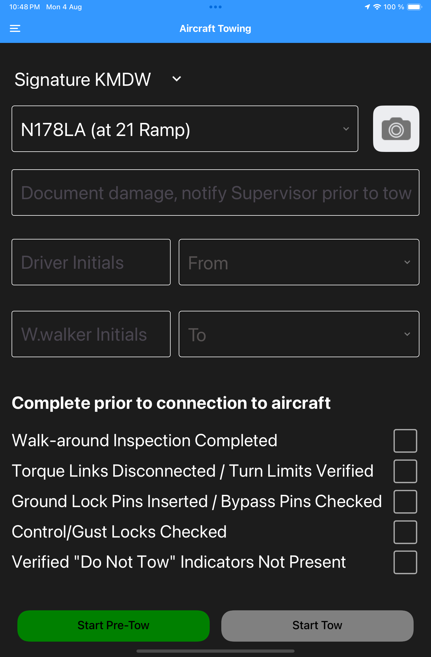
Aircraft towing
Document arrival condition with notes and pictures, run pre-tow checklists, and track every second of aircraft movement, live and historically.
Ramp inventories
Document aircraft positions in two taps, and generate parking reports.
Ground vehicle tracking
Track vehicles wherever they are within the airport's perimeter.
In our customers’ own words...
We measure our success by yours!
“This is the best software I’ve ever used! The ease at which I can see the information I need is astounding.”
Paso Robles Municipal Airport
“This software has been a game-changer for our team. It’s intuitive, reliable, and saved us countless hours—exactly what we needed to streamline our work!”
French Valley Airport
"We’ve tried other solutions, but this one stands out. The support is top-notch, and it just works seamlessly every time. Highly recommend!
Teterboro Airport
“This is the best software I’ve ever used! The ease at which I can see the information I need is astounding.”
John Glenn Columbus International
“This software has been a game-changer for our team. It’s intuitive, reliable, and saved us countless hours—exactly what we needed to streamline our work!”
Dekalb-Peachtree Airport
"We’ve tried other solutions, but this one stands out. The support is top-notch, and it just works seamlessly every time. Highly recommend!
Wittman Regional Airport
Meet the team
We are a select team of experienced technologists, pilots and problem solvers committed to making the most out of your organization's operational data.


Founder and CEO
1200.aero, Inc. | Raleigh, NC